Today we’re talking about our experience hiking to Nevado Santa Isabel (Poleka Kasue in the Quimbaya language), one of the most easily accessible volcanoes in Los Nevados Natural Park, but also one of the symbols of the global effects of climate change.
We hadn’t been back to Los Nevados Natural Park for over 10 years. So we decided to mark the occasion by climbing the north summit of the Santa Isabel volcano.
A challenge for us who had never hiked at such a high altitude!
In this post, we tell you all about our acclimatization, the hike to Laguna Verde and our attempt to climb Nevado Santa Isabel. It’s also an opportunity to talk about melting glaciers, climate change and the beauty of the Colombian mountains.
Good to know
Los Nevados Natural Park closing dates
No entry is permitted on these days:
- april 21 to 25th, 2025
- may 19 to 23th, 2025
- september 22 to 26th, 2025
- november 24 to 28th, 2025
Contents
Related posts

General information Los Nevados Natural Park
- Protected area: Los Nevados National Nature Park
- Ecosystem: Cloud forest, Paramos, Glaciers and Volcanoes
- When to go: Year-round
- Surface area: 583 km2
- Temperatures: between 3°C and 14° C
- Climate: Cold and humid
- Minimum altitude : 2600 m
- Maximum altitude : 5300 m
- Region: Andes
- Departments: Quindio, Tolima, Risaralda, Caldas
- Access: Pereira, Salento, Manizales, Ibague, Murillo

The Travel insurance we recommend in Colombia
We live in Colombia, and we can confirm that private healthcare is very expensive here. Private clinics in Colombia generally only admit patients who have insurance.
Coverage up to 2.5 M€ · 24/7 assistance in english · Hospitalization · Medical evacuation · Luggages
Excellent · 4,6/5 · Trustpilot · 1 599 review
Santa Isabel, acclimatization and preparations
Trek to Santa Isabel volcano, Los Nevados Park

Before our trek to the Santa Isabel volcano, we had the good idea of spending a few days in Murillo, a small mountain village located between Honda and Manizales, on the slopes of Los Nevados Natural Park.
Our acclimatization
Murillo is located at an altitude of 3,000m and is the perfect place to acclimatize for a few days before tackling the high peaks of Los Nevados Natural Park.
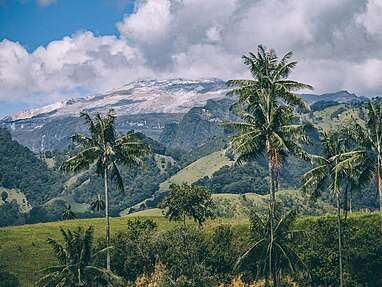
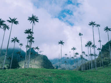
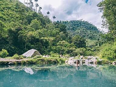
We spent 3 nights at over 3000m and did some hiking around the village. It was an opportunity to discover a new destination that blew us away! Thermal baths, wax palms, spectacular scenery… and the Nevado del Ruiz still looming on the horizon.


To read
We then set off for Manizales, the starting point for transport to the Nevado Santa Isabel trek. On the way, we decided to try out the excursion to Nevado del Ruiz.
Despite our misgivings, the visit turned out to be quite enjoyable, and it also enabled us to climb to an altitude of 4500m without any effort (the excursion is by vehicle).


To read
Our experience in Nevado del Ruiz
We can assure you that these few days of acclimatization not only allowed us to make some great discoveries, but also prepared us perfectly for what lay ahead (spending a night at over 4000m and hiking up to 4800m)
Good to know
Mountain hazards in Colombia
Colombian mountains are nothing like European (or North American)mountains. The very high altitude combined with the equatorial climate make the Colombian mountains particularly dangerous, and unless you’re a seasoned mountaineer accustomed to setting off on your own with the proper terrain preparation (reconnaissance, map) and safety equipment (GPS, Radio, Arva, etc.), you’ll need the presence of a certified local guide.
Here’s why:
- Rescue services: there are no rescue services in the mountains (the army can send a helicopter)
- Weather: there are no seasons when you can be sure of good weather. On the contrary, above 4000m, the chance of rain, hail, cold and fog is 99%.
- Markings: mountain trails are not marked in Colombia.
- Maps: There are no topographical maps of hiking trails in Colombia
- Refuges: There are no refuges in Colombia. They are usually agricultural farms that provide accommodation, but where the hosts are not trained in mountain rescue. What’s more, if you get lost, you can go for days without seeing a refuge.
- Altitude: with peaks over 5000m, the risk of altitude sickness is high
- Informal guides: there are many informal guides (with attractive prices) who are not trained in risks or rescue.
Our trusted partner
As you can see, even if you think you’re an experienced trekker, we don’t recommend going into the Colombian mountains without a guide.
Our local partner is a mountain agency specializing in the Los Nevados Natural Park, which only works with certified and official guides, recognized by the authorities and trained in the specific risks of high-mountain trekking.
Safety and responsibility are their top priorities:
- 1 guide for a maximum of 3 hikers
- Official guides authorized by Colombia’s national parks
- Guides trained in (very) high mountain risks
- Perfect knowledge of the terrain
- Safety equipment (radios, gps, etc.)
What’s more, they offer a preparatory meeting for each hike, where you can find out what conditions to expect, what equipment you’ll need, and ask any questions you may have. From our point of view, this is an essential step that demonstrates their professionalism and attention to detail, as well as their concern for hikers’ safety.
Favorite local agency
Trek to Nevado Santa Isabel
Day 1 – Hike to Laguna Verda
Hike to Nevado Santa Isabel, Los Nevados Park

It’s the big day! We meet Felipe, our guide, at 6 a.m. to set off by car for Nevado Santa Isabel. it’s a 3-hour drive from the Villamaria vereda, where we have breakfast, to the El Cisne refuge, the starting point for the hikes to the volcano.
From Manizales, we’ll once again enjoy the exceptional experience of navigating between Colombian thermal floors and seeing nature transform as the road climbs, from cloud forest at 2200m to super páramo at 4100m.
After a minor technical mishap, we finally arrive at the refuge to enjoy a good lunch. The refuge is superbly well equipped and comfortable. According to Felipe, it’s quite simply the most beautiful refuge in Colombia… It’s one of the few true mountain refuges managed as a concession to the natural parks by a community association.


After lunch, we set off on our (real) acclimatization hike. We headed for Laguna Verde at 4500m altitude. It’s an easy hike, allowing us to test our mettle over a short distance (6km) and a reasonable altitude difference (350m D ).
The hike will also allow us to test all our equipment! We set off in the sunshine and the desire to shed a few layers of clothing, but ended up in the rain, wind and fog, bundled up to the max to resist the cold.
It’s a gentle hike in the company of Felipe, an attentive and patient guide and a wealth of knowledge about the Los Nevados natural park, which he has considered his playground since he was a child.
Felipe familiarizes us with our surroundings, with this incredible super paramo ecosystem where thousands of frailejones proudly sit, and with the majestic mountains that surround us: Volcan Ruiz, Volcan Santa Isabel, Volcan Olleta, Volcan Cisne, etc.
We arrive at Laguna Verde in the rain. As the fog begins to lift and the cold chills our hands, we put on our gloves and wait for a miracle. And here it is! A gap in the fog, the lake revealed for a moment, then gone.
We finally return to the refuge with a few certainties and a few doubts too…


Doubts, certainties and a decision
We had come to climb the north summit of Santa Isabel. That was our primary objective.
But after this first day’s effort, the afternoon’s weather and the difficult night ahead (we slept at 4100m), we were in doubt.
This day at Laguna Verde has been a milestone in our hiking “history”. Today’s 4500m represents the highest altitude we’ve hiked to date. Tomorrow, the north summit of Santa Isabel is announced at 4965m and we’re in doubt.
It’s 6pm, and after a hearty meal, Felipe trains us in the mountaineering equipment we’ll have to use on the glacier tomorrow (crampons, ice axes, ropes, helmet, etc.). Another mark of professionalism and seriousness. We’ll have to carry more weight than today, and we’re in doubt…
Felipe listens. He doesn’t force anything. He accompanies us in our reflection, giving us information about the difficulties, but also the great sensations that await us.
It’s pouring down around the refuge. We’re dreading tomorrow’s difficult weather, the prospect of getting up at 2am and doing most of the climb at night. We’re in doubt…
Felipe doesn’t make us feel guilty; he encourages us to do it, of course, but always leaves the door open to our final choice. That’s the hallmark of a great guide. And Felipe is a great mountain guide.
It’s decided, we won’t do the summit.
For us, the simple challenge of altitude that we’ve been experiencing for the past few days seems more than enough.
We love walking, the scenery, the beauty of the mountains… but we’re not obsessed by the idea of reaching a summit at any price.
So we’ll simply walk as high as we can. That’s the challenge we’ve decided to set ourselves. A step that will allow us to test ourselves and find out whether or not we might be able to make the ascent to the summit one day.
(Spoiler alert: of course we could).
Topo Laguna Verde
Information and itinerary
- Distance: 5km
- Duration: half-day hike
- Departure altitude: 4150m
- Arrival altitude: 4500m
- Elevation gain: approx. 350m
- Difficulty: easy
- Climate: very cold and wet
- Equipment required: waterproof hiking gear (shoes, jacket, waterproof pants and gloves, hats, etc.)
- Acclimatization: Recommended
Favorite local agency
Trek to Nevado Santa Isabel
Day 2 – Climate Change Trail – Nevado Santa Isabel
Trek to Poleka Kasue volcano, Los Nevados Park

The following day, we were lucky enough to get up a little later than planned. By 4:30 we were dressed and sitting down to a hearty breakfast to build up our strength.
Felipe gives us the snacks carefully prepared by the agency. We finish dressing and packing: thermal underwear, hiking pants and fleece, rain jacket and pants, hat, gloves, 2L of water with mineral salts, cameras, etc.
It rained all night and snowed on the summits! As we leave the refuge, we can see the imposing shadow of the Nevado del Ruiz overhead in the night, its summit covered in a white blanket…
We set off from the refuge in a 4×4 to the trailhead. On the way, the sun rises over the snow-covered Nevado del Ruiz… A volcano that usually only appears in grey tones due to its daily ash sprays… The volcano’s fumaroles, illuminated by the first rays of sunlight, blaze into the sky…
An unreal vision!


The tone is set. The mountains have decided to spoil us today.
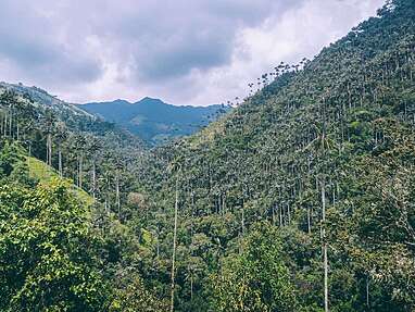
It must be 6:30 a.m. and we start the “Climate Change Trail” at first light. This trail was created in 2018 and was originally intended to take hikers right up to the edge of the Santa Isabel glacier.
Except that the glacier no longer exists , making the trail’s theme all the more meaningful.
We don’t know it yet, but the work we’ve done to show the evolution of the glacier’s melting will have a major impact. Walking to the summit and seeing with your own eyes how climate change has destroyed an ecosystem thought to be as unchanging as glaciers is a real eye-opener.
The walk is slow, the effort is constant, but once again it’s a hike that’s really accessible to everyone (we’re in good health, but we’re not sporty).
Only the altitude affects our bodies, but our fine acclimatization over the last few days has taken its toll and we won’t feel any symptoms. Just goes to show, even if you’re prone to altitude sickness (like Samuel), good acclimatization is essential if you’re going to enjoy the trip to the full!
The skies are clear, the sun is shining and we’re treated to some spectacular panoramas. The Nevado del Ruiz greets us in all its splendour. The contrast between the Paramo’s glowing landscapes and the volcano’s glacial lunar summit is breathtaking.


As for Santa Isabel, she’s playing hide-and-seek.
It’s hard to imagine what its northern summit looks like, but in the distance we can see a tiny glimpse of the glacier! We climb up a ridge and finally arrive in the lair of the Santa Isabel volcano. Opposite us rises the central summit with its unmistakable shape.
The landscape becomes increasingly rocky.
And the higher you climb towards the Santa Isabel peaks, the more you see the phenomenon accelerating. Along the way, several educational panels show the glacier’s evolution over time. The last panel shows what the edge of the glacier would have looked like in 2022.


Today there’s nothing left.
To be here, in this cirque of stone where, just a few years ago, a glacier that has now completely disappeared “lived”, is food for thought. What was once an ice cap covering the three Santa Isabel peaks no longer exists.
Good to know
Climate change trail
The Nevado Santa Isabel is one of the most studied glaciers in the world. The speed with which the Santa Isabel Glacier has seen its glacier melt has put it on the world map of endangered glaciers.
In 2013, the Conejeras trail, a historic transit trail within the park, was opened to tourism following the closure of access from the northern zone of the Nevado del Ruiz.
In 2018, IDEAM (Colombia’s national meteorological institute) releases a report showing that in two years (between 2016 and 2018),the Nevado Santa Isabel glacier has lost 37% of its surface area, a process never before recorded in such a short time on a global scale.
This has led to the realization that this glacier is likely to disappear for good in the next few years, and the desire to create this “climate change trail” that would show the evolution of the glacier’s melting from the first records in the 19th century to the present day.
and the theme of the “climate change trail” is the result of research
A first-rate educational project carried out between IDEAM and the Technological University of Pereira, supervised by Professor Manuel Tiberio Flórez, a doctoral student in environmental sciences.
The project links science and tourism, and aims to raise visitors’ awareness of the seriousness of the phenomena linked to climate change.
The Climate Change Trail features a number of panels showing the different locations of the glacier from 1850 to 2022, the last date before the total disappearance of the global glacier that covered all the Santa Isabel peaks.
This awareness-raising work is fundamental to the interpretation of the climate crisis, as it allows us to measure the extent of glacier loss and to reflect on the consequences for the region, particularly in terms of water security.


In front of us, we can imagine the central summit covered in ice. Behind the central summit lies the south dome, whose ice cap has also completely disappeared. To the north, if we crossed this rocky bar to the left, we’d be waiting for the north summit, where we’d originally gone to put on crampons, and the few hundred m2 of glacier remaining, the last vestige of a disappearing ecosystem.
Throughout our ascent, the clouds rising from Manizales pursued us. As we reached the foot of the central dome, the sky became overcast, the fog rose and the cold stung our skin. As if the sky was telling us it was time to go back down, it was time to leave to avoid any problems.
And yet, for a moment, we might have thought that perhaps we could swallow the remaining 200m of ascent to the central summit of Santa Isabel.


But we put on our gloves, hats and rain pants and prepare ourselves for a difficult descent. But it’s not to be. A few drops later, the descent takes us out of the fog and we finish the trail in clement weather.
The fatigue felt over the last few hundred meters puts into perspective the desire for a summit that had arisen at the foot of the central dome…
Exhausted, but full of gratitude for the Colombian mountains we love so much, we set off again for Manizales, in the hope of returning one day to tread the last blocks of ice on the north summit of Santa Isabel before they disappear forever.
As you may have guessed, the aptly named “Climate Change Trail” reports on the evolution of the melting Santa Isabel volcano glacier. It bears witness to part of the recent history of Colombia’s mountains. You can observe the glacier’s retreat over the last 170 years, and whether you want to reach the summit or not, it’s a hike we 100% recommend!
Today, all equatorial glaciers in Colombia are disappearing.
Topo Climate Change Trail
Information and directions
- Distance: 8km
- Duration: one-day hike
- Departure altitude: 4150m
- Arrival altitude: 4780m
- Elevation gain: approx. 600m
- Difficulty: medium
- Climate: very cold and wet
- Equipment required: waterproof hiking gear (shoes, jacket, waterproof pants and gloves, hats, etc.) hiking bag. dress in layers.
- Acclimatization: Recommended
Favorite local agency
Trek to Nevado Santa Isabel
Topo Nevado Santa Isabel in detail
Trekking in Nevado Santa Isabel, Los Nevados Park

Nevado Santa Isabel is an active, dormant volcano that last erupted in 1943. It is a strato-volcano composed of a series of arched domes with three distinct summits: the north dome (4965m), the central dome (4934m) and the south dome (5100m)
In 2025, only the north dome will still have a small ice cap.
General info
- Spanish name of volcano: Santa Isabel
- Indigenous name of volcano: Poleka Kasue
- Volcano type: strato-volcano
- Glacier type: equatorial glacier
- Maximum altitude: 4965m (north dome), 4934m (central dome), 5100m (south dome)
- Access: via Manizales or Pereira, the shortest route being via Manizales.
- Birthplace of rivers: Rio Otún and Rio Claro (tributaries of Rio Cauca), Rio Azul and Rio Torarito tributaries of Rio Recio and Rio Totare respectively, themselves tributaries of Rio Magdalena.
- Location: Los Nevados National Park, between the departments of Caldas, Risaralda and Tolima
Topo Nevado Santa Isabel
If you’d like to climb the north summit of Santa Isabel, the only summit where you still have to cross a small section of glacier before reaching the summit, here are the practical details of this hike.
- Distance: 11km
- Duration: one-day hike
- Start: around 2 a.m., mostly nocturnal ascent
- Starting altitude: 4150m
- Maximum altitude: 4965m
- Ascent: approx. 800m
- Difficulty: high
- Climate: very cold and wet
- Equipment required: mountaineering equipment (boots, crampons, ice axe, helmet, etc. supplied by the agency, except boots), 30-liter hiking bag. headlamp. dress in layers.
- Acclimatization: Recommended
Regulations
Due to the fragility of its ecosystem, access to Nevado Santa Isabel is regulated by Colombia’s national park authorities.
- Park entrance fee: $65.000 COP (foreigners)
- Reservations required at least 3 days in advance
- Access limited to 30 people per day
- Must be accompanied by a certified guide
- Must visit the “Campo Alegre” office of Colombia’s natural parks
Our local partner handles all permissions and reservations required to enter the park.
Favorite local agency
Trek to Nevado Santa Isabel
Poleka Kasue, a vanishing glacier
Trek to Volcan Santa Isabel, Los Nevados Park

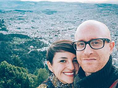
Since the dawn of time, the snow-capped peaks of Los Nevados Natural Park have been visible on a clear day from cities as far away as Bogota and Medellin, inspiring dreams (or fear) and fuelling fantasies.
In the not-too-distant future, neither we, nor you, nor anyone else will see the snow-capped peaks of the Cordillera Central on the horizon.
Colombia’s glaciers are among the few equatorial glaciers in the world. “Ecuador” and “ice” are not words we easily associate in our minds. And that’s why they are so important to climate scientists.
According to IDEAM, the Quindío volcano glacier disappeared in 1960. Between 1850 and 2021, the glaciers of the Ruiz and Tolima volcanoes lost more than 80% of their surface area. And today, the Santa Isabel volcano is covered by less than 1% of the glacier it had at the time of the first scientific observations.
This melting has accelerated sharply in recent decades, mainly due to global warming. The phenomenon has beenexacerbated by the volcanic activity of the Nevado del Ruiz. Ashfalls from the Ruiz volcano onto the Santa Isabel glacier have helped accelerate melting by reducing the glacier’s ability to reflect the sun’s rays.
In less than twenty years, the glacier that once covered the entire 3 summits, forming a single mass of ice, fractured into separate fragments, eventually disappearing completely from the southern and central summits.
As nature abhors a vacuum, melting glaciers will be accompanied by changes to ecosystems. And what today is a vast, lifeless scree will in a few decades’ time become a super-paramo and a páramo, ecosystems that are fundamental to feeding the region’s watersheds and the Magdalena River.
The inevitable end of the Santa Isabel glacier should, however, make Colombians and the world aware of the importance of protecting high mountain ecosystems.


2025
We were there at the beginning of February 2025 and the central dome glacier had completely disappeared.
Contact a local guide
Best local mountain agency
Responsible tourism
Our partner is the first trekking operator in Colombia to have been awarded the Tourcert certificate, and is working to develop a responsible tourism policy:
- Application of ” Leave no trace ” principles
- Joint work with National Park authorities
- Guides certified in high-mountain first aid
- Safety and responsibility (radio equipment, 1 guide for max. 3 people, etc.)
- Employment of local people with fair wages
- Contribution to the local economy with the aim of improving working conditions
- Commitment to local communities (school tool collection programs)
Where to stay in Manizales
Manizales

Finca
Hotel Lodge Paraiso Verde
This is where we stayed in Manizales. It’s a beautiful, carefully restored traditional coffee finca located on the outskirts of the city. The meals are excellent, and it’s also a great spot for birdwatching.
Manizales

Finca
Hacienda Venecia
One of the most renowned coffee fincas around Manizales, offering both high-end accommodations and hostel-style lodging (see opposite). An option worth considering, just 30 minutes from Manizales.
Manizales

Finca
Hostel Hacienda Venecia
This is the “hostel” section of Hacienda Venezia — a more budget-friendly accommodation option, while still enjoying a peaceful retreat surrounded by nature.
Manizales

Hostal, Hotel
Hostel Golden Frog
A hotel right in the heart of Manizales, perfectly located to enjoy the city, and a peaceful place to stay where warm hospitality and comfort await!
How to get to Manizales
From Murillo
By bus
- Duration: 4 hours
- Fare: $40.000 COP
- Company: Rápido Tolima
- Times: 6 am and 2 pm
By car
- Driving time: 2h30
- Distance: 85km
Traffic restrictions Murillo – Manizales road
Since October 2024, traffic restrictions have been in place on the road between Manizales and Murillo with the aim of reducing traffic congestion and mitigating environmental impacts in the buffer zone of Los Nevados NPN. This environmental “Pico y Placa” is implemented every weekend and is applied according to the last license plate number. For further information: Natural Park of Colombia
From Pereira
By bus
- Duration: 1 hour 45 minutes
- Price: $20.000 COP
- Company: Empresa Arauca
- Schedule: frequent
By car
- Driving time: 1h30
- Distance: 50km
From Bogota
By bus
- Duration: 10 hours
- Fare: $75.000 COP
- Company: Bolivariana, Expreso Palmira, Empresa Arauca
- Schedule: frequent
By car
- Distance: 290km
- Driving time: 8h
From Honda
By bus
- Duration: 4 hours
- Price: $65.000 COP
- Company: Copetran
- Schedule: frequent
By car
- Distance: 140km
- Driving time: 3h30
From Salamina
By bus
- Bus or shared cab from Manizales bus terminal
- Bus time: approx. 3h / Taxi time: approx. 2h
- Fares: $25.000 COP
- Company: Autolegal
- Schedule: frequent
By car
- Distance: 75km
- Driving time: 2 hours